Hi guys! Lemon here.
Often as I look at the forest territory map for the clans (you know, the one that comes in the front cover of warriors books) I feel it doesn't really do the territory justice. Things are emphasized and stylized for artistic reasons, and while the map art is pretty, it fails to interpret the full scale of just how big the forest territories really are.
Here's my reasoning for this:
1. One outdoor cat will have a territory of about a 2 mile diameter. Now think of how big of a territory a full clan would need, it would have to be huge.
2. An average healthy cat can walk about 5-10 miles a day. Considering that canonically in the books, ThunderClan medicine cats would have to wake up early in the morning to journey to Highstones, one could say Highstones is about 5-10 miles away from camp.
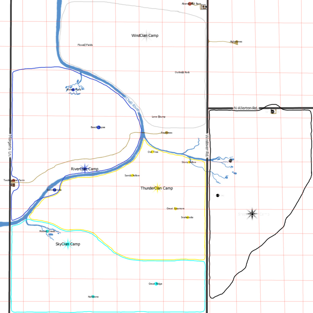
To give a visual of just how big the territories really are, I've composed some rough maps below:
This is a plain mockup of the territories.
Every red square is exactly one mile. This would add up to my theory, as it would take a ThunderClan cat about 7 miles to get to Highstones, and a SkyClan cat about 10. (That's why they have such toned legs *wink wink*)
Knowing this, one can judge what time one would need to leave camp to get to Highstones.
SkyClan: Crack of dawn
ThunderClan: Early Morning
RiverClan: Before Sunhigh
ShadowClan: Early Morning
WindClan: Sunhigh
Each clan's territory is about 20 square miles, give or take. This would give enough space for a clan to function and have enough food for all the cats. This is also why when hunting patrols leave camp, they don't come back until sunset. They're traveling
miles to find food. The forest territories aren't some twoleg park. They're a large swath of forest.
Now let's look at another map:
This is an altitude map. The blue shades are the lowest parts of the land, while the red shades are the highest parts of the land. Remember the Newleaf flood last year? This is why everyone ran to Highstones. This is also why ShadowClan is incredibly marshy, as it is a reservoir for a river.
And finally, here's the last map:
This is a terrain map, plotting out all the different kinds of vegetation around the forest territories.
Gray: Barren land with hardly any vegetation.
Brown: Shrubland with sparse trees and tall grass.
Light Blue: Wetlands, incredibly marshy, prone to flooding.
Yellow: Plains, hardly any trees grow here.
Light Green: Light Deciduous Forest. Sparse forest that will lose its leaves in the winter.
Dark Green: Thick Deciduous Forest. Very thick forest that will lose its leaves in the winter.
Light Teal: Light Evergreen Forest. Sparse forest that stays green during the winter.
Dark Teal: Thick Evergreen Forest. Very thick forest that stays green during winter.
Feel free to click or download any of these maps for a larger view of them. If you'd like to use these for roleplay, keep in mind that a healthy cat can only travel 5-10 miles in one day. This is a good way to judge how long it will take to get from one point to another. Love you guys! I hope this makes it a tad bit easier to properly judge the expansive size of this forest!


